


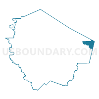
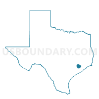
Voting District 1134, Fort Bend County, Texas
About
Outline

Summary
| Unique Area Identifier | 673123 |
| Name | Voting District 1134 |
| County | Fort Bend County |
| State | Texas |
| Area (square miles) | 10.66 |
| Land Area (square miles) | 10.48 |
| Water Area (square miles) | 0.18 |
| % of Land Area | 98.29 |
| % of Water Area | 1.71 |
| Latitude of the Internal Point | 29.56674370 |
| Longtitude of the Internal Point | -95.45202720 |
Maps

Graphs
Select a template below for downloading or customizing gragh for Voting District 1134, Fort Bend County, Texas


Neighbors
Neighoring Voting District (by Name) Neighboring Voting District on the Map
- Voting District 0050, Brazoria County, TX
- Voting District 0131, Harris County, TX
- Voting District 0722, Harris County, TX
- Voting District 1003, Fort Bend County, TX
- Voting District 2017, Fort Bend County, TX
- Voting District 2034, Fort Bend County, TX
- Voting District 2036, Fort Bend County, TX
- Voting District 2055, Fort Bend County, TX
- Voting District 2108, Fort Bend County, TX
- Voting District 2116, Fort Bend County, TX
- Voting District 2123, Fort Bend County, TX
- Voting District 2136, Fort Bend County, TX
Top 10 Neighboring County Subdivision (by Population) Neighboring County Subdivision on the Map
- Houston CCD, Harris County, TX (3,075,388)
- Alvin-Pearland CCD, Brazoria County, TX (176,301)
- Stafford-Missouri City CCD, Fort Bend County, TX (131,732)
Top 10 Neighboring Place (by Population) Neighboring Place on the Map
- Houston city, TX (2,099,451)
- Pearland city, TX (91,252)
- Missouri City city, TX (67,358)
- Fresno CDP, TX (19,069)
Top 10 Neighboring Unified School District (by Population) Neighboring Unified School District on the Map
- Houston Independent School District, TX (1,312,684)
- Fort Bend Independent School District, TX (348,526)
- Alvin Independent School District, TX (86,711)
Top 10 Neighboring State Legislative District Lower Chamber (by Population) Neighboring State Legislative District Lower Chamber on the Map
- State House District 27, TX (225,449)
- State House District 29, TX (208,164)
- State House District 131, TX (152,889)
Top 10 Neighboring State Legislative District Upper Chamber (by Population) Neighboring State Legislative District Upper Chamber on the Map
- State Senate District 17, TX (847,887)
- State Senate District 11, TX (838,090)
- State Senate District 13, TX (730,086)
Top 10 Neighboring 111th Congressional District (by Population) Neighboring 111th Congressional District on the Map
Top 10 Neighboring Census Tract (by Population) Neighboring Census Tract on the Map
- Census Tract 6606.02, Brazoria County, TX (26,843)
- Census Tract 6708, Fort Bend County, TX (14,354)
- Census Tract 6709.01, Fort Bend County, TX (10,214)
- Census Tract 6706.01, Fort Bend County, TX (8,975)
- Census Tract 3308, Harris County, TX (8,571)
- Census Tract 6702, Fort Bend County, TX (8,322)
- Census Tract 3307, Harris County, TX (7,796)
- Census Tract 6701.01, Fort Bend County, TX (6,801)
- Census Tract 6709.02, Fort Bend County, TX (5,020)
- Census Tract 6703, Fort Bend County, TX (3,801)
Top 10 Neighboring 5-Digit ZIP Code Tabulation Area (by Population) Neighboring 5-Digit ZIP Code Tabulation Area on the Map
- 77584, TX (70,228)
- 77459, TX (56,274)
- 77489, TX (35,554)
- 77053, TX (28,954)
- 77583, TX (28,531)
- 77047, TX (21,077)
- 77545, TX (19,431)